I have been quite surprised at how effective of a navigation tool an iPad or iPhone can be. To date the only limitations I have noticed is the rechargeable battery, but in the many circumstances with the right software I actually prefer the iPhone or iPad to a standalone real GPS.
One of the most common concerns I hear about the iPhone is in regard to its durability. But, the right case can solve that (OtterBox or Lifecase).
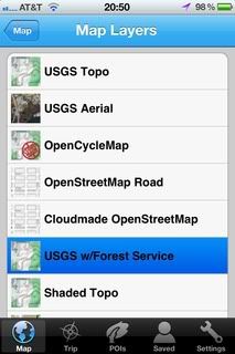
The key to making the iPhone a usable GPS unit in the field is the right software. I use a number of different programs depending on what I am doing. All of these programs allow maps to be downloaded and stored directly on the iPhone.
GaiaGPS($9.99),
GPSKit($9.99), and
PDF Maps(Free).
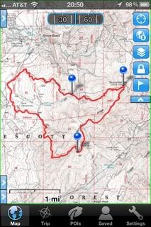
GaiaGPS is probably the best GPS application for most users, and all indications are that it is only going to become more versatile with future updates. GaiaGPS allows you to download maps in a number of formats and import (and export) GPX and KML files. When downloading map files you not only choose the area you want but also the zoom level to customize the file to your needs and available space. I have tried a number of GPS/Map applications (47 to be exact) looking for the best one. GaiaGPS is the best GPS application for backcountry navigation I have found.
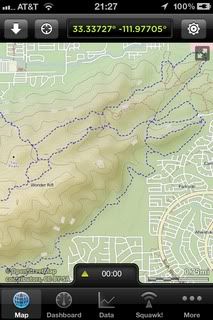
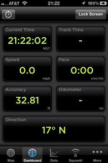
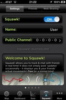
GPSKit is a close second to GaiaGPS, but the GaiaGPS greater (and simpler) map options give the advantage over GPSKit. That being said, GPSKit is a slightly better application for working with KML and GPX files, and I still use it when I am working with very large GPX or KML files. GPSKit does have some features GaiaGPS doesnt have; A dashboard screen (that is similar to the Garmins Trip Computer screen) Squak mode which allows you to share your location and other information with other GPSKit users (I havent tried this feature).
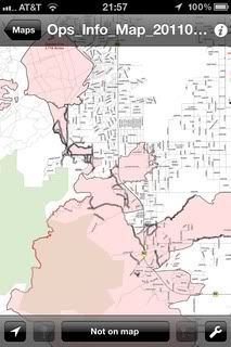
PDF Maps is a free application, and actually pretty limited (compared to GaiaGPS of GPSKit) in what you can use it for. However, it has one feature that makes it an absolute must have (especially since it is free). PDF Maps is simply a reader for GeoPDF files, with a few navigation tools added. GeoPDF are PDF maps coded with location data. You can download these directly from the built in store in PDF Maps (many of the maps are free) or from USGS website and many National Forest websites. The navigation functions are more limited but is does allow you to mark waypoints, import KML files, Geo-code photos (which the iPhone does already) and import and export KML and GPX files. I primarily use this app to view the GeoPDF maps at wildland fires.
I do still use my real GPS units, but find myself doing so less and less. With portable solar charges and smaller and lighter battery packs becoming available, the iPhone will only become more usable in the field as a GPS unit. The battery life isnt really that bad as it is, with normal settings (everything on) my iPhone 4 will run for more than 24 hours with my normal level of usage. If I am using it as a GPS in the backcountry I set it to Airplane mode (the GPS still works in this mode), in this configuration using GaiaGPS for tracking I have been able to track for over 5 hours and still have well over half my battery life remaining. I have not used the iPhone to track longer than 5 hours.
While still not a replacement for a paper map and compass, the iPhone is starting to replace my real GPS units more and more.


 Previous Topic
 Index
Index


