Before I was a paracord junky, I was (and still am) an outdoorsman with a love of off-trail exploration. It was my efforts to make myself a better set of pacing beads for land- nav that jumpstarted the knotting frenzy I find myself in today. Land navigation with traditional skills that include dead reckoning. Recording distance travelled through pace count or distanct/time relationship along with direction allows you to find your way back, even if you dont have a map. With a map, you can plot your courses AND use terrain recognition and baselines to re-calibrate your location as you go. I will never rely on the GPS, only use it to supplement a traditional approach that has guided explorers, sailors and aviators in the past.
Pace count is important, and a way to keep track like ranger beads helps. Also, experience and calibration will give you a good pace number for certain distances under a variety of terrain conditions. When exploring off trail for fun I enjoy honing my skills by creating my own map, plotting (to-scale) the courses of my travel (bearing and distance) on paper using my simple $10 silva baseplate compass. If I reach a point where I want to wander a bit, I tie up a piece of bright survey flagging, or my orange handkerchief at the location of the end of my last course so I can come back (keep it in sight) and resume.
Draw a north arrow on your sheet (I keep a little rite in the rain notebook with grids); use the lines on the paper for n/s reference or draw your own to aid in proper compass placement on the paper to transfer a real world bearing onto paper. if you stick with magnetic north and are plotting your own map, you need not worry about declination. I think this skill allows you to safely hit the woods for some exploration when you may have otherwise not if you didnt have a pre-printed map. Also, with this method, your course can change as field conditions warrant and you'll always have a map back to the start. When you reach an obstacle like a swamp or lake, you dont need to use the oversimplified techniques of doing a couple of uniform 90 degree or 45 degree turns and expect to be around your obstacle and on the right course. You have the freedom to adjust your direction as real conditions require, and always know your current position relative to where you started and can set a bearing for home!
What many people dont realize is that because what you are plotting for distance is all relative (in similar terrain); you can even plot "paces", or time traveled rather than "distance"! This works as long as you determine a scale and stick to it (ie. so many inches = so many paces, or so many minutes).
Here are the field notes from a little jaunt I took 4 years ago; note that since I was in similar type terrain the whole time so there was no major adjustments required for terrain changes. I didn't plot distance OR pace count, instead I plotted TIME - again this works because its all relative! You can see I chose one block to represent 2 minutes, then I kept a log of bearing/start/stop travel time. I love this stuff!
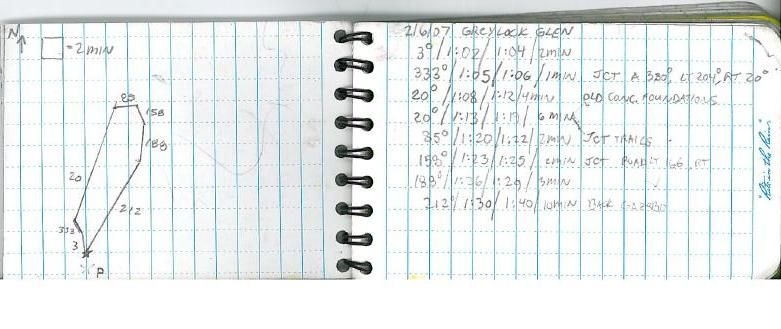
When plotting time, you must adjust if you have a very easy segment, then some really tough terrain you must realize that you'll cover more ground in the same amount of time on the easy segment and adjust accordingly. this is similar in concept to adjustments you make to pace count in varying terrain.


 Previous Topic
 Index
Index


