California Wildfires- Nov.

Posted by: TeacherRO

California Wildfires- Nov. - 11/09/18 07:03 PM

The fires are large and growing rapidly -- and the evacuation orders cover a large segment of the population.
Posted by: hikermor

Re: California Wildfires- Nov. - 11/10/18 01:21 AM

Currently, something like 75,000 homes are affected in eastern Ventura County, but there are something like 30 million folks living in SoCal, so really the percentage of the population affected isn't really all that high...Small comfort if you have to evac.

From our house we can see massive smoke to the east in the vicinity of Thousand Oaks and Camarillo. Locally a power transformer blew this morning, so we got to use some of our emergency gear and review procedures. To my chagrin, one of my power banks was completely discharged, but the solar panels were working well.

Events like this just keep you tuned up and aware.
Posted by: hikermor

Re: California Wildfires- Nov. - 11/10/18 02:20 AM

Update - make that 250,000 people under evac orders
Posted by: Pete

Re: California Wildfires- Nov. - 11/11/18 06:03 PM

Good morning Hikermor. I havent had a chance to get a good look at the fire situation this morning, Sunday. There are very strong Santa Ana winds today. That cant be a good thing. I am guessing that you have better local knowledge of where these fires are burning.

One problem with the fire maps on Google - it is not clear which direction the fire is going. Also, it is hard to know how recent the latest information is. If you happen to see a better source of info, please post.

For those people not in So Cal, most folks here in CA are not panicked. But as Hikermor explained, these fires are a tragedy for people living in Thousand Oaks, Calabassas, and Malibu. A very dangerous situation when the flames jump major roads, and people are trying to escape in their cars.

We send prayers for all those caught up in this disaster, and we hope they have found safe temporary accommodations.
Posted by: Herman30

Re: California Wildfires- Nov. - 11/11/18 06:44 PM

Here is a site where you can see how the winds are blowing.

https://www.windy.com/?37.344,-114.203,6
Posted by: Pete

Re: California Wildfires- Nov. - 11/11/18 09:31 PM

Thank you Herman30. That chart of wind patterns is a great piece of information!
Posted by: Pete

Re: California Wildfires- Nov. - 11/11/18 09:35 PM

I notice that there is an argument growing between Washington DC and the State of California ... about the costs of these wildfires.

I have no intention of getting involved in the politics.

Let me simply say this. California has an enormous quantity of dead brush, all over the western side of the State. This has been caused by many years of droughts. Our long-term weather cycle is getting much drier. In addition, many of our forests contain large proportions of dead pine trees. These trees were killed by pine bark beetles. In some forests, the dead trees are 40%, or 50%, or 60% - or more - of the total tree coverage. This is not true of all the CA forests, but it is certainly true in parts of Southern California and the Sierras.

It is completely impossible for Californians to log out all the dead timber, or remove all the dry underbrush. The economics make this impossible.

For this reason ... it is easy to make the prediction ... the worst days of California wildfires still lie AHEAD of us.

How Washington DC will handle this ... I cannot say. But I wonder if the USA national expense for emergency disasters (hurricanes, floods, wildfires) is starting to look like a rising exponential curve?
Posted by: Russ

Re: California Wildfires- Nov. - 11/11/18 11:00 PM

I’d say a few controlled burns are in order, but in this day and age that might be considered political. Seems like everything is politicized these days.
Posted by: rafowell

Re: California Wildfires- Nov. - 11/11/18 11:50 PM

Originally Posted By: Pete
...One problem with the fire maps on Google - it is not clear which direction the fire is going.

Keeping in mind that evolution of wildfires is somewhat unpredictable, you can see the evolution over the last ~48 hours if you go to GeoMAC, zoom to regional level, select "Data Layers", then "Satellite Fire Detection", then "HMS Fire Detection", you will see the "current" fire marked red, prior 24 hours yellow, prior 48 hours, grey. Similar color coding applies to the other satellite data layers.

However, I would think that prediction of where the fire wants to go would be of extreme interest to incident commanders, so I am a bit surprised we don't see a GIS approach to this, factoring in weather, topography, and fuel.

From WildFireToday.com:

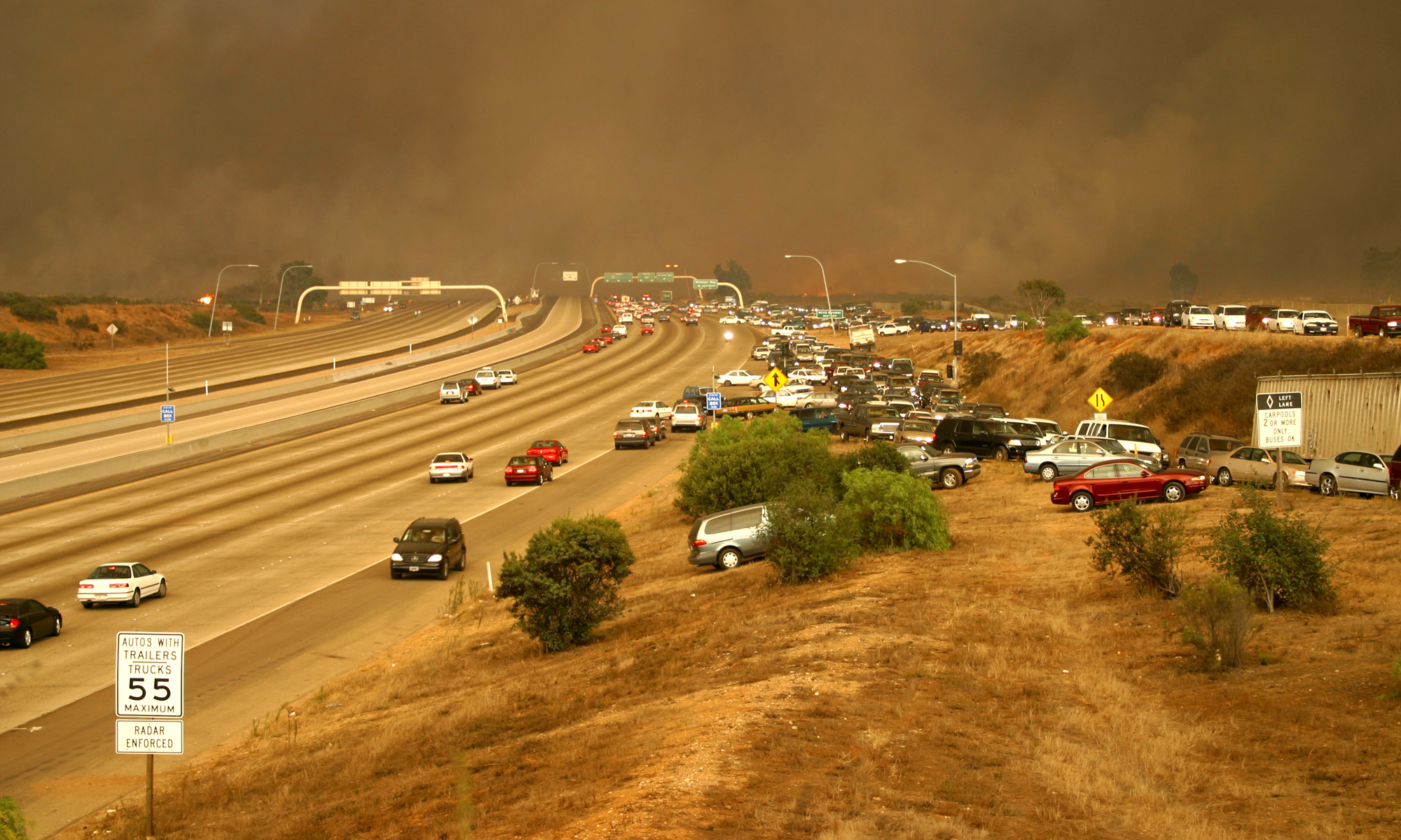
10:00 PM PST Nov 10 2018: snapshot of the Woolsey Fire
12:04 PM PST Nov 9, 2018: snapshot of the Woolsey Fire
Originally Posted By: Pete
Also, it is hard to know how recent the latest information is.

On GeoMAC, there is a legend below the map saying what the epoch of the data is supposed to be. As I type this, for the Woolsey fire, it says:

"Thermal MODIS 2018-11-11 1514 (MDT); VIIRS 2018-11-11 1104 (MDT); HMS 2018-11-11 900 (GMT); Fire Perimeters 2018-11-11; Situation Reports 2018-11-11 1944 UTC"

I don't know if those are "last update times" or "data was true at" times.

The currency of the satellite fire data is somewhat predictable, since the satellite passes are published. For the satellite fire data displayed on GeoMac, here's what GeoMAC has to say, followed by my thoughts:

MODIS

"This thermal data is collected twice a day, at 2:00 PM EST and again at 12:00 AM EST and are then processed and merged into a single map, which is available by 3:00 AM EST." {My thoughts: the example above suggests more timely processing, since at 14:41 PST the map says it has MODIS data from 13:14 PST, shich should be the MODIS pass from around 13:00 PST. The MODIS satellites pass overhead 4x per day, around 10:30 AM/PM and 1:30 AM/PM (plus or minus an hour).[1],

VIIRS IBAND

"It provides data from the Visible Infrared Imaging Radiometer Suite (VIIRS) sensor aboard the joint NASA/NOAA Suomi National Polar-orbiting Partnership (SNPP) satellite. The 375 m data complements MODIS fire detections; they both show good agreement in hotspot detection but the improved spatial resolution of the 375 m data provides a greater response over fires of relatively small areas and provides improved mapping of large fire perimeters. The 375 m data also has improved nighttime performance. Consequently, these data are well suited for use in support of fire management (e.g., near real-time alert systems), ... The VIIRS IBAND layer is updated every two hours. However, there may be gaps in daily coverage. If we have received no new data, the "expired" layers are not replaced. The layer is replaced as soon as we receive an updated file." { Updates every 2 hours are far better than once every 24, but this instrument is only on the Suomi-NPP satellite. You can find the NPP Orbit Track online, but the passes are basically 1:15 AM and 1:15 PM, plus or minus an hour.

Originally Posted By: Pete
If you happen to see a better source of info, please post.

Currently, the best "one-stop shop" for fire maps seems to be GeoMAC .

The traditional "goto" site for wildfires, InciWeb, underwent an update this March that made it harder to find information on a particular fire. However, if you go to their LINKS section,there's lots of good stuff there. In particular, it lists the regional coordination centers. The Southern California Geographic Area Coordination Center links to the "Current Fire Information" at Cal Fire which links in turn to the Woolsey Fire Incident Report

The GeoMAC online fire viewer from USGS is pretty good, and lets you isolate fire detection from four different satellite systems. It also has a button (top right) for optimized viewing on mobile devices.

[1] Details:
The "truth time" of the MODIS satellite data will depend on when the satellites with the MODIS sensor (Terra and Aqua) pass over the fire scene. From Wikipedia - Terra and Aqua are "sun synchronous", meaning they pass over any ground point twice per day, and any equatorial point at the same solar time, quantized by the fact that there are only about a dozen orbits per day, so the closest pass may be east or west of you - your nearest pass will be about +/- 1 hour of the "ideal" time. Terra passes over the equator at 10:30 PM descending, so about 10:20 PM over Woolsey. The prior pass is 10:30 AM ascending, or 10:39 AM over Woolsey. Aqua crosses around 1:30 AM/PM. For more detail, see: Terra Track Aqua Track

Posted by: Pete

Re: California Wildfires- Nov. - 11/12/18 01:55 AM

"I’d say a few controlled burns are in order"

its essential.
i dont know how political it is. its the one strategy that might save California at this time. best done in winter. i hope they go ahead with it.

thanks for the comment.
Posted by: Pete

Re: California Wildfires- Nov. - 11/13/18 04:45 PM

I am taking a look at the map of the fires on Google, this morning. Tuesday. I look at it each morning and night. It is difficult to say, but the fire perimeter does not seem to have moved. That conflicts with 'reality' because the news says that the fire (Wolsey fire) is only 30% contained. It would be very helpful if Google showed its map with two-colors. A blue zone that marks the perimeter of the fire yesterday, and a red zone that marks todays perimeter.

I can say that the Santa Ana winds here in So Cal are the strongest that I have ever seen them. We live in the mountains, so we see the winds directly. The wind gusts are very powerful, certainly as high as 40 mph, and I would guess that some gusts may be up to 50 mph. That is certainly making the conditions for fire fighting very difficult in So. California.

Authorities are investigating whether these fires started from power lines that were swaying in the winds, and creating sparks. That is surprising. It has certainly happened in the past, but our utility companies are getting smarter. They now shut down power to regions where there are strong winds. But maybe their info is not completely accurate.
Posted by: Russ

Re: California Wildfires- Nov. - 11/13/18 05:15 PM

The article I read indicated the winds at the point of failure may have been higher than at where the wind speeds are measured. Why Did The Catastrophic Camp Fire Start Where It Did? It’s informed speculation, but possibly correct.
Posted by: hikermor

Re: California Wildfires- Nov. - 11/14/18 02:31 PM

Originally Posted By: Pete
"I’d say a few controlled burns are in order"

its essential.
i dont know how political it is. its the one strategy that might save California at this time. best done in winter. i hope they go ahead with it.

thanks for the comment.


Controlled burns are currently in use in California and elsewhere, and have been in the forest manager's toolbox for several decades, but controlled burns must be used with great care, when weather and fuel moisture conditions are right. Even then, there can be problems. The last fire on which I worked was an escaped controlled burn on Santa Cruz Island.

there are adverse results from any burn (smoke, charred landscape, etc.) so some people become understandably grumpy.

Even when controlled burns are in use, it takes some time for the results of the policy to become evident.
Posted by: Russ

Re: California Wildfires- Nov. - 11/14/18 03:17 PM

From what I’ve seen in Malibu, this latest uncontrolled burn seems to show that controlled burns have not been used even close to enough. There may be liability concerns in that if a controlled burn becomes uncontrolled, who gets sued, whose insurance company pays and who is made whole by the state... (warning Will Robinson, political boundary approaching)

There are many opinions as to how fires could be mitigated: from let mother nature take its course, to stop all fires immediately at whatever cost; but allowing fuel to build up over years/decades and then having a spark from a high voltage line ignite that fuel during a Santa Ana (hot, dry, high winds) is probably not the best option. That said, it seems the let mother nature run its course, while we valiantly attempt to gain control is the option that has been chosen. Let PG&E’s insurance company pay...

We in the popcorn gallery seem to have no say.
Posted by: chaosmagnet

Re: California Wildfires- Nov. - 11/14/18 03:41 PM

A family member’s house was destroyed years ago by a controlled burn that went wrong.

I suspect that there’s a lot of room for improvement in policy over where houses are built, fire breaks, and the like.
Posted by: hikermor

Re: California Wildfires- Nov. - 11/14/18 05:08 PM

Part of the problem is that the urban/semi urban development is expanding into the wildland-urban interface (WUI). You have a beautiful scenic setting, surrounded by fire ready kindling. Typically access and egress is at least moderately difficult.

Years ago (1956) I had my first job fighting forest fires in Arizona. I remember that our instructor remarked then that fighting fires in California chaparral was the most dangerous environment. The situation hasn't changed, except for more development in the WUI.
Posted by: Pete

Re: California Wildfires- Nov. - 11/14/18 05:12 PM

Good point Hikermor. It is a very dangerous situation for the firefighters. Today, Wednesday, the Santa Ana winds are still very strong. This is a very tough week for everyone involved in the firefighting effort. Congratulations to them for their great efforts!
Posted by: Jeanette_Isabelle

Re: California Wildfires- Nov. - 11/14/18 05:20 PM

I don't know if there is anything that can be done except clear the land. I'm not talking about a controlled burn.

The trees that the forest fires have destroyed could have been put to good use. I am aware that there are people who object to that. To them, I say: We can either clear some trees or you can watch as California burns. It's your call.

As much as I want to comment on what I think their response would be; we have to leave politics out of it.

Jeanette Isabelle
Posted by: Jeanette_Isabelle

Re: California Wildfires- Nov. - 11/14/18 05:36 PM

Deleted.
Posted by: Pete

Re: California Wildfires- Nov. - 11/14/18 05:43 PM

Here is a new story from N. California. This story explains why the problem was so serious there, and why many people could not escape the fire. One lady hid overnight, by submerging herself (and her dogs) in a pond in the neighbor's backyard.

https://www.aljazeera.com/news/2018/11/c...4055154134.html
Posted by: Pete

Re: California Wildfires- Nov. - 11/14/18 05:47 PM

Jeanette ... i think most people in the USA dont understand the situation in California. The western half of CA is absolutely covered with dry brush and chaparral. It is everywhere. It has accumulated through many seasons of growth, then it turned dry through nany years if drought. It is impossible for us to remove all of the old dry grass and weeds. The volume of work required to do this is enormous ... it is beyond the capability of everyone. So that is the problem.

When I read these stories, like the tragedy of the Paradise fire, I dont say to myself ... those people made bad choices. I say to myself ... the same thing could happen here where I live .. exactly the same situation. And many, many other people in CA are saying the same thing. I live in a valley that has one access road ... only one way in and out. The whole valley is covered in dry grass and chaparral. The mountains have a lot of dead trees. It is a natural fire trap.
If a sudden fire happened, many people could be trapped in this valley. People always figure ... well we have time to escape. But in a fast-moving fire ... you dont always have time to escape. The local authorities are well aware that there is a high fire risk, but they just do not have the money to clear all of the dead grass.

The same situation exists in many local towns and regions across CA. it is a big, big problem.

Posted by: Jeanette_Isabelle

Re: California Wildfires- Nov. - 11/14/18 06:07 PM

Originally Posted By: Pete
I say to myself ... the same thing could happen here where I live .. exactly the same situation.

I've looked at worse situations and said the same thing only to be dismissed: "You worry too much. There's nothing to worry about."

Jeanette Isabelle
Posted by: Jeanette_Isabelle

Re: California Wildfires- Nov. - 11/14/18 06:22 PM

Originally Posted By: Pete
Jeanette ... i think most people in the USA dont understand the situation in California. The western half of CA is absolutely covered with dry brush and chaparral. It is everywhere. It has accumulated through many seasons of growth, then it turned dry through nany years if drought. It is impossible for us to remove all of the old dry grass and weeds. The volume of work required to do this is enormous ... it is beyond the capability of everyone. So that is the problem.

When I read these stories, like the tragedy of the Paradise fire, I dont say to myself ... those people made bad choices.

Sorry, I should have asked for clarification. Is this in response to my comment on clearing trees, developing intelligently or both?

Jeanette Isabelle
Posted by: hikermor

Re: California Wildfires- Nov. - 11/14/18 07:21 PM

A bit o historical perspective - Here in the country west of Los Angeles, inhabited by the Chumash, Native Americans, it was customary to intentionally set fires periodically to clear openings or travel and provide food for native animals (which were then available or hunting). This doesn't mean that they didn't suffer catastrophic fires from time to time - archaeologists encounter burned structure fairly regularly.

There is definite suspicion that native Americans on balance did a better, more sustainable job of managing the vegetation that more recent inhabitants, whose initial response was total fire suppression across the board, now being modified to strategies that seem similar to those in place long ago..

A properly managed controlled burn in not at all like the conflagrations we are seeing currently, which is why conditions have to meet very strict criteria. A good controlled burn will burn at low intensity, spread at a moderate rate, consuming grasses and other light fuels, and leaving mature trees untouched. When done properly, you do not get the accumulations of flammable fuel which stoke the fires so prominent now on TV.
Posted by: Russ

Re: California Wildfires- Nov. - 11/14/18 07:44 PM

Yep. As long as there is excess fuel, wind, and an ignition source there will be wild fires.

Fuel is something we could control but for various reasons have chosen to not control. I’m sure firefighters would much rather have strategically planned, controlled burns during calm, cool weather conditions, than fight a fire that is uncontained and driven by hot, dry, high winds.

It’s very difficult to stop a Santa Ana from blowing, so the only remaining item we can control are various manmade ignition sources (power lines, camp fires and signal fires (see Cedar Fire). I’d be remiss if I didn’t mention the occasional arsonist, we’ve seen those too. High school kids iirc.

Besides sitting back with a bowl of popcorn, all I can do is plan for a forced evacuation when the next fire starts east of here driven by the wind. BTDT on three occasions, truck was packed and ready, didn’t leave the garage

Maybe the fire burning through Malibu will get the attention of folks who write big checks, and get a conversation started with the folk who make decisions.
Posted by: Russ

Re: California Wildfires- Nov. - 11/14/18 09:39 PM

This picture from the wiki link above brings back memories. For some reason the few commuters working that day didn’t want to drive through the smoke.

“Drivers scramble up the embankment to escape from Interstate 15, as the Cedar Fire crosses the freeway.”

It’s a shot taken looking to the north on I-15 where it runs through MCAS Miramar. As evident in the picture, the fire jumped I-15. Fortunately, there wasn’t much fuel and room to run on the airfield side (left in the picture), so the fire was stopped right there. This was one of the rare occasions I found myself wearing an N-95 mask to drive. That was miles north from where the picture was taken, the air wasn’t quite as thick. This is one reason I bought a real respirator.
Posted by: Pete

Re: California Wildfires- Nov. - 11/15/18 04:24 PM

Wow. I just saw a pjoto from the hills of Malibu, after the fire. ALL the vegetation is gone. There is nothing but charred ash. That was a seriously-hot fire.

We are accustomed to seeing burned-out areas here in California. Usually the grass is gone, and there are charred tree stumps. But over at Malibu ... nothing ... nada. Very dangerous. Just what Hikermor said .. California chapparal is high risk when it starts to burn.

Thanks for comments about respirator. True enough. There has been very thick smoke here.

This winter I will have to seriously consider moving to another town. There is no sense in staying in a valley that is a fire trap. It's just playing Russian roulette. The town authorities in CA are never going to solve these problems.

RE Controlled Burns - I dont know who calls the shots. It probably has to be made at the local level i.e. town authorities, or home-owners associations. The problem in CA is that these local authorities are filled with dead-wood. I am talking about the management level. They wont make smart decisions. Partly it is because of risks and legal consequences. If a controlled burn did get out of control, they would be financially liable. But beyond that, CA is criss-crossed by a myriad of local rules that dont make any sense. So local groups of home owners just say ... well, a fire disaster didnt happen here yet, so maybe we will just get lucky in the future. No-one will get off their b*tt and do something if it requires major initiative. In addition, CA house owners usually refuse to pay extra money for new measures anyway. So everything becomes deadlocked at the local level. And people just sit around, waiting for the inevitable.

There is no rule or law that compels people to FIX these problems.
Posted by: hikermor

Re: California Wildfires- Nov. - 11/15/18 06:36 PM

Generally controlled burns are conducted by whatever group is managing the land to be burned - USFS for the Los Padres NF, or the NPS for Santa Monica NRA (which really took it on the chin in this latest fire).

Generally the constraints are the budget (imagine that!) and the right conditions, which are often rare to absent. Any fire controlled or not, generates smoke and inconvenience, so there will be complaints.

On an individual level, there is a lot one can do. Control the brush adjacent or close to your residence, put screening on vents and other openings (helps with rodent control as well). There are protective coatings which can be applied, advertised as being long lasting.

Above all, be organized and aware. Mrs. Hikermor and I evacuated last year from the Thomas fire. It didn't come out of the blue - vegetation was parched, winds were forecast, and the scrub on the hills near our house was tall and fire ready. We had a little chat about a week before the fire ignited, discussing location of papers, vehicle readiness, etc. When it was time, we were loaded and gone in about fifteen minutes - could have been quicker if necessary. Our insurance, including earthquake, is paid up.

Mostly, before the emergency, prioritize and determine what is really necessary and irreplaceable, like the Japanese Nambu pistol my Dad liberated in WWII..

Fires are a recurring problem. This was the third time in thirty years that I have loaded up ready to go, but the first time I actually left.

I haven't seen the picture you refer to, but it sounds like a typical aftermath...
Posted by: Jeanette_Isabelle

Re: California Wildfires- Nov. - 11/15/18 06:59 PM

Originally Posted By: hikermor
Mostly, before the emergency, prioritize and determine what is really necessary and irreplaceable, like the Japanese Nambu pistol my Dad liberated in WWII..

I agree. I wish there is a way to do that.

Jeanette Isabelle
Posted by: Russ

Re: California Wildfires- Nov. - 11/15/18 09:59 PM

Re: the respirator — California's Deadliest Fire ... Air Chokes Residents
Quote:
...The smoke from the Camp Fire, which has burned 140,000 acres, claimed at least 56 lives, and is 40% contained, is so bad that anyone in the cities of Chico or Gridley who venture outdoors without a surgical-grade respirator are putting themselves in danger, according to Bloomberg. ...

Posted by: katarin

Re: California Wildfires- Nov. - 11/16/18 02:47 AM

I am down in Sacramento the air quality here is now at hazardous. I am not sure how many miles Paradise is/was from here.
Posted by: CANOEDOGS

Re: California Wildfires- Nov. - 11/21/18 06:45 AM

the tent citys going up around the fire areas are a heads up on
what to expect after the Big One.