PLB or GPS?
Posted by: LeeG
PLB or GPS? - 03/25/13 08:25 PM
I have been doing several of the short hikes around the Phoenix area over the past few years. My hiking partner and I are planning on some longer point-to-point hikes through the Superstition Mountains, still single day hikes, but longer, sunrise-sunset type hikes. I have good topo maps of the area we will be hiking and a good compass. I am planning some longer overnight hikes for this fall after the weather cools back down. I have a bit of extra cash that Uncle Sam decided to let me keep, so I was pondering getting either a plb or a GPS. The PLB would be one of the ACR ResQLink and GPS would probably be a Garmen.
My pack currently contains: maps, compass, fire steel, rei matches, lighter, tinder, hydration bladder (3L), Ritter PSK, heat sheet, bivy sack, first aid kit, blister kit, some emergency bars, 10' rope, 50' para cord, headlamp, flashlight, poncho, fleece jacket, sun screen, extra socks, EESE 4 knife, leatherman, whistle, and spare batteries. I also carry my iPhone and a camera.
For this hike, I'll be bringing 4-6 liters of water (12 miles with no water sources) plus the usual trail food. I'd appreciate any comments or suggestions.
Lee
Posted by: hikermor
Re: PLB or GPS? - 03/25/13 08:38 PM
What is the nature of the your cellphone coverage in that area? That would a key factor. I imagine you are planning to do these trips fairly soon. By May the Supes get pretty toasty.
The storm predicted for this coming weekend should wet things down fairly well.
Your gear list looks pretty good. What is ten feet of rope for?
I don't believe you mentioned a signal mirror. Take about five minutes and learn to use it. Well worth it, especially in the American Southwest.
Posted by: LeeG
Re: PLB or GPS? - 03/25/13 10:04 PM
I have a signal mirror in my PSK. The rope is something I have used a few times to help or be helped on the short sections of the trail that involve short but vertical climbs.
I really can't afford both a plb and a GPS at the moment. I can and have gotten by without either so far. There is decent cell coverage over large portions of this trail, but not so much on some others I will be doing.
Posted by: Russ
Re: PLB or GPS? - 03/25/13 10:28 PM
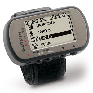
Anyone doing serious recreation should carry a PLB. As for GPS receivers, since you already have a map, you really only need a basic Garmin. The
Foretrex 301 is a solid basic unit (~$130 on Amazon). Teamed with a map (matching waypoints on each), you have a great back-up to your navigation.
Many emergencies start with getting lost. Your goal is to do everything you can to never need to activate the PLB. But it's still there when you need it.
Posted by: Denis
Re: PLB or GPS? - 03/25/13 10:28 PM
From a pure risk mitigation perspective, I think the PLB wins. Loosing your way isn't the only situation you could need one, but injury, unexpected weather or animal attacks are other situations where it could be needed (for example). It gives you a way to get help no matter the emergency.
That said, when facing the same decision I went for the GPS (and I pretty much never have cell service where I go). I ultimately decided that staying found was more important to me than having a lifeline for those less likely, but potentially life threatening, situations.
Posted by: hikermor
Re: PLB or GPS? - 03/25/13 10:30 PM
I was struck by the very short piece you mentioned. I usually carry a light climbing rope when in rough country,even when the plan calls for sticking to the trail. But I would carry a minimum of sixty feet, and one hundred feet is often preferable. At a diameter of 8 or 9 millimeters, the weight is tolerable. This strategy has paid off several times for me.
One more suggestion. Do you contemplate any overnight trips? If so, I feel it would be preferable to invest in a quality sleeping bag, and/or tent, or conceivably, upgrade your backpack. I would put any of those items at a higher priority than either a PLB or GPS. In the Superstitions or most of the country in Arizona or similar environs, you will do very well with quality maps and terrain association.
I would agree with Russ with respect to the Garmin 301, which is the model I use. But I would put either electronic appliance at a lower priority than acquiring a good, basic set of backcountry gear, and acquiring substantial first aid training.
Your iPhone has a pretty decent GPS engine built in especially if you have an iPhone 5 combined with some excellent electronic mapping apps. (they want to keep tabs on you down to the nearest couple of square meters)
You could always use it in conjunction with a SPOT connect and use their App to send satellite text messages to Twitter/Facebook etc.
http://www.findmespot.com/en/index.php?cid=116
Posted by: bacpacjac
Re: PLB or GPS? - 03/26/13 10:00 AM
You'd get more use out of a GPS and hopefully stay found with it., but getting lost is only one of the reasons you might need rescue. Take a look at your risk factors illness and injury while weighing these two options.
Also, please remember to file a detailed trip plan with someone you know is responsible. Talk with them about when to initiate a search. Have an agreed upon plan for your hike and your rescue, and then stick to it. If you deviate while you're out there, let them know ASAP. IMO, if you can't confidently update them of changes, don't deviate from your route.
Like Bacpacjac said, you will actually use the GPS more, but the PLB can save your life. You may only use it once, but that one time could be very important.
Posted by: Glock-A-Roo
Re: PLB or GPS? - 03/26/13 01:56 PM
I say buy the PLB and use the GPS capabilities of your phone, especially since you're in an area without a lot of tree cover. Learn how lat/lon & UTM coordinates work, carry a good gridded map, and then all you'll really need is point position from your phone's GPS. Everything beyond that is gravy.
Over time you'll become very adept and familiar with keeping up with your position on the map, helped along as needed with occasional GPS fixes. Then when you get some extra cash you'll have a bit of a clue as to features to look for in a GPS.
It's win-win. You get the immediate safety factor of a great PLB, and you then enhance your knowledge and understanding of the things that make GPS truly useful.
Posted by: Denis
Re: PLB or GPS? - 03/26/13 03:49 PM
Learn how lat/lon & UTM coordinates work, carry a good gridded map, and then all you'll really need is point position from your phone's GPS.
That's a really good point. I now have an iPhone app (
Tom's GPS) that will display your location using UTM coordinates. Other than saving waypoints (like the location of the car, camp, etc), I primarily use my GPS to give me the UTM coordinates so I can pin-point where I am on my map.
Posted by: Russ
Re: PLB or GPS? - 03/26/13 06:32 PM
Interesting iPhone App if it works. I installed the Tom's GPS App on my iPhone 4S and turned airplane mode on to simulate no cell coverage. The App would not display a location until I turned airplane mode off. Then it immediately gave me a location. The problem as I see it with relying on a cell phone for "GPS" location data, is that the cell phone is not a GPS receiver.
From
http://gps.about.com/od/glossary/g/A-GPS.htm:
...Assisted GPS, also known as A-GPS or AGPS, enhances the performance of standard GPS in devices connected to the cellular network. A-GPS improves the location performance of cell phones (and other connected devices) in two ways:
-By helping obtain a faster "time to first fix" (TTFF). A-GPS acquires and stores information about the location of satellites via the cellular network (see almanac) so the information does not need to be downloaded via satellite.
-By helping position a phone or mobile device when GPS signals are weak or not available. GPS satellite signals may be impeded by tall buildings, and do not penetrate building interiors well. A-GPS uses proximity to cellular towers to calculate position when GPS signals are not available....
From the short down the block test I just did, once I determined the system would not give a location without access to the cellular network, I gave it a signal, got a fix and then went back into airplane mode. It took about 1 minute for the Toms GPS app to go blank. IOW, without the cell network, the app doesn't seem to work.
A-GPS assumes GPS signals may become weak or not available while the places people may really run into navigation problems that are life threatening are where cell signals are weak or not available. I will not be relying on a cellphone for navigation.
If others have different experience, please weigh in and let me know what I'm missing. TIA
Posted by: chaosmagnet
Re: PLB or GPS? - 03/26/13 06:36 PM
Airplane mode turns the GPS receiver off on the iPhone. Go to Settings/General/Cellular and turn Celullar Data off to simulate off-grid use with the GPS receiver turned on.
Posted by: Russ
Re: PLB or GPS? - 03/26/13 06:39 PM
Thanks. Didn't know that, although I should have, Airplane mode turns off a lot of functions. Now I'll need to remember to turn them back on.

Outside, back in a bit.
Edit: Crow tastes great. The Tom's GPS app works and the accuracy with my iPhone is close enough to not matter. Outside it was showing an accuracy of 10 m; inside it's showing an accuracy of 200 m. Still, close enough for a back-up.
I don't have an iPhone but an iPod instead with no inbuilt GPS engine. The Garmin Glo GPS Bluetooth reciever works very nicely with the iPhone mapping system apps on the iPod.
What is important to improve GPS accuracy is HDOP and VDOP which is related to the Sky View and number of Satellites. You could for example put the Garmin Glo under your hat or in a top pouch in your Rucksack. This will improve the number of Satellites your GPS antenna/engine will see.
The Garmin Glo GPS is specified to pick up GPS and GLONASS signals from both constellations and will typically see around 12-18 satellites rather than just the 6-9 GPS NAVSTAR satellites. This could be useful if the NAVSTAR constellation system goes down.
The update rate is also 10 times that of conventional GPS engines.
Maximum Accuracy would typically be;
GPS - 8-10 metres with Selective Availability turned off
GPS + (WAAS or EGNOS) - 5-8 metres
GPS + (WAAS or EGNOS) + GLONASS i.e. the Garmin Glo - 2-3 metres
DGPS - 1-2 metres depending on baseline distance
RTK GPS (phase measurement with small baseline distances) - 0.01-0.02 metres
In the UK the mapping accuracy for OSGB36 grid mapping is typically 2-3 metres for a OSGB map triangulation point so DPGS and RTK GPS would be rather pointless for general navigation.
Posted by: AKSAR
Re: PLB or GPS? - 03/26/13 08:19 PM
If I feel the need to carry a GPS, my personal preference is to carry a dedicated GPS (Garmin in my case). I will sometimes also carry my iphone, but I look at it as strictly a back up for the Garmin.
My reasons for not relying on the iphone as my primary GPS are listed below. I do realize there are ways to mitigate some of these issues, and I've noted some of those.
1. Most smartphones are rather fragile and are not waterproof. In back country situations it is all to easy for a smartphone to be knocked out of action, probably when you need it most. However, one could put a smartphone into a protective case, and there are some available that are more rugged than the iphone.
2. GPS tends to use a lot of battery. I can easily replace the batteries in my Garmin in the field. Recharging my iphone requires getting back to a plug in. Again, there are options to recharge smart phones in the field, but this means carrying more stuff with no other purpose.
To summarize, in the rugged areas I frequent, I get by 98% of the time by using terrain association with a map. I always carry a compass, but seldom need it. I often carry a GPS, mostly for fun, but now and then it can be priceless (in a whiteout for example). I often carry my iphone (in a ziploc bag, deep in my pack), but consider it only a back up.
Those are my personal choices. As always, your mileage may vary.
Posted by: Glock-A-Roo
Re: PLB or GPS? - 03/26/13 08:28 PM
For Android users, check out "Field Compass +". It uses the phone's 3-axis compass to show a traditional baseplate compass view. You can sight on a target and essentially set the 'compass' bezel with a screen tap, then box the needle at the azimuth you've set. Works just as well as a simple Silva compass. An info pane on the bottom edge shows your GPS coords in the format and datum you select. There is no waypoint recording, routing, or GPS tracking.
The GPS phone app I use is "GPS Essentials". It has a highly configurable dashboard and full waypoint/route/track features. It has mapping functions but I haven't messed with those.
My phone is a Motorola Razr Maxx which has phenomenal battery life. And I would run these apps occasionally, not continually. Since I'm toting the phone anyway, it makes sense to have serviceable navigation apps on it as backups.
Posted by: AKSAR
Re: PLB or GPS? - 03/26/13 08:42 PM
......
Maximum Accuracy would typically be;
GPS - 8-10 metres with Selective Availability turned off
GPS + (WASS or EGNOS) - 5-8 metres
GPS + (WAAS or EGNOS) + GLONASS i.e. the Garmin Glo - 2-3 metres
DGPS - 1-2 metres depending on baseline distance
RTK GPS (phase measurement with small baseline distances) - 0.01-0.02 metres
In the UK the mapping accuracy for OSGB36 grid mapping is typically 2-3 metres for a OSGB map triangulation point so DPGS and RTK GPS would be rather pointless for general navigation.
Even 8-10 meters of accuracy is probably more than sufficient for most outdoor purposes. (Exceptions might be geocaching and a few other applications.) Back in the dark ages before GPS, we sometimes thought we were doing pretty well to locate ourselves within a 100 meters (depending on terrain). Ah.... but I am showing my age

Of course I'm a bit biased from living in Alaska. For many areas outside town, the best available topo maps date from the '50s and '60s, and are at 1:63,360. In really remote areas some of these were done with very sketchy primary geodetic control, and there are some serious accuracy busts in some places (this shows up when one tries to splice two paper maps together). Areas closer to major towns have been revised more recently, and in a few places we are lucky enough have recent 1:25,000 maps, but those are exceptions.
Posted by: Denis
Re: PLB or GPS? - 03/26/13 10:40 PM
Of course I'm a bit biased from living in Alaska. For many areas outside town, the best available topo maps date from the '50s and '60s, and are at 1:63,360.
This is similar to Canada, while the maps may be newer (and are undergoing updating) we only have 1:50,000 topo maps that are widely available. I've seen a couple private 1:20,000 & 1:35,000 maps, but only for a few limited areas.
Posted by: hikermor
Re: PLB or GPS? - 03/27/13 01:48 AM
If you really want to have fun, you should use the 1930s era 15 minute quadrangles that were the only USGS maps available in the mid 50s when I first started using topo maps. They were drawn by teams traveling by pack trains, using a plane table and alidade. Sometimes they goofed on terrain contours, but the trails were absolutely spot on. By contrast, when the new generation of 7 1/2 minute quads came out a few years later, the topography was right on, but trails were erratic, sometimes quite fanciful.
Posted by: bacpacjac
Re: PLB or GPS? - 03/27/13 01:49 AM
Thanks. Didn't know that, although I should have, Airplane mode turns off a lot of functions. Now I'll need to remember to turn them back on.
Outside, back in a bit.
Edit: Crow tastes great. The Tom's GPS app works and the accuracy with my iPhone is close enough to not matter. Outside it was showing an accuracy of 10 m; inside it's showing an accuracy of 200 m. Still, close enough for a back-up.
This is a great example of what I love about ETS! Shared experience to increase the knowledge of us all. thanks Russ!
Posted by: AKSAR
Re: PLB or GPS? - 03/27/13 02:17 AM
If you really want to have fun, you should use the 1930s era 15 minute quadrangles that were the only USGS maps available in the mid 50s when I first started using topo maps. They were drawn by teams traveling by pack trains, using a plane table and alidade. Sometimes they goofed on terrain contours, but the trails were absolutely spot on. By contrast, when the new generation of 7 1/2 minute quads came out a few years later, the topography was right on, but trails were erratic, sometimes quite fanciful.
Actually I have used a few of those old maps. When I was a lad growing up in the Pacific Northwest, and starting to climb in the Cascades, those were the only maps available for some of the peaks. But since I am but a mere youngster (at least when compared to geezers like you
) it was in the mid '60s for me.
I think the reason trails were spot on on those old maps is because the only way those old guys could map was to hike up the trails to the ridgetops, carrying the plane table and alidade on their backs. They probably stopped at every few switchbacks, and plotted them in while catching their breath. But since there would always be some portions of the terrain hidden from any vantage point, they had to sometimes use a little "artistic license" with the contours.
Posted by: hikermor
Re: PLB or GPS? - 03/27/13 03:14 AM
Exactly. I think some of the newer generation maps must have been ground truthed in the rear booth of a convenient country tavern.
Posted by: Russ
Re: PLB or GPS? - 03/27/13 02:48 PM
YW. If anyone does get in a situation where they are out of cell coverage and using an iPhone for navigation, battery power management is something to keep in mind. Turning off items using Airplane mode is a great way to get just about everything powered down. Bluetooth and Wi-Fi can be turned on regardless so make sure they are also turned off unless you need them. With mine, going to Airplane mode turns them off, then I turn them back on separately if needed.
Apparently, turning location services on does not work the same way. As Chaos said, for the internal GPS to work, Airplane mode needs to be turned off (meaning phone stuff is turned on) and then individual items like cell coverage, wi-fi and bluetooth need to be turned off individually. Since you can't change batteries in an iPhone, managing the power you have is rather critical. $.02
Posted by: LeeG
Re: PLB or GPS? - 03/27/13 06:33 PM
Thank you everyone for the replies. I have decided to go ahead and get the PLB first, and then perhaps by this fall when hiking season comes around again, I'll get a GPS. For this upcoming hike, I am really more worried about an injury than getting lost. I do have a compass, paper maps, and my iPhone with some good GPS software and downloaded maps.
I'd still like to get a GPS for reasons that a few have mentioned. Mainly ease of battery replacement and not draining the batteries on my primary communications source.
Posted by: widget
Re: PLB or GPS? - 03/28/13 03:06 PM
Lee, I am in Phoenix and have hiked, backpacked and rock climbed all over the Superstitions. My means of navigation was always a map and compass. One of the hiking maps sold by Wide World of Maps is a good trail map to help navigate with up to date trail information.
I started hiking the superstitions in the early 1960's and there were almost no houses around, roads were vague and the trails were not at all crowded, you could hike all weekend without seeing another person. Not that way today, most trails are pretty well travelled. So, assistance is more available, perhaps.
Since I am older now, I too worry about an injury, especially when hiking alone. You can find yourself pretty far from the car and with an injury that slows you down, or stops you, it can be life threatening. I have also had almost no cell coverage (Verizon) once over the first ridge inside the Supes. The phone drains the battery rapidly seeking a signal that is not available. So, I don't have much faith in a cell phone out there.
The iphone has the added disadvantage of a fixed battery, so once it is dead, there is no changing it out.
I will add that although I own 3 hiking GPS units, I have never carried one in the Superstitions. The landmarks are pretty well defined out there and it makes orientation with a map and compass very easy. The beauty of the PLB is you can signal for help, which a GPS can't do.
Posted by: chaosmagnet
Re: PLB or GPS? - 03/28/13 03:14 PM
When I'm hiking with my iPhone somewhere that there isn't good signal, here's what I do:
- I start by preloading terrain maps onto my iPhone -- the built-in apps for mapping don't allow that
- I mark important locations, like the trailhead, where I parked my car, my campsite, and so on
- Then I power down the phone and navigate with map and compass
With a good case and a small recharger in my pack, to me it's a reasonable way to not need to spend money on a dedicated GPS. If I do get lost I can fire it up and figure things out without worrying that the battery will go dead due to continuously looking for a cell tower signal.
A dedicated GPS is a better way to go for a lot of people, especially if they're in areas they don't know well or are difficult to navigate.
Posted by: Russ
Re: PLB or GPS? - 03/28/13 03:53 PM
In this situation a PLB is definitely the way initially. However, basic GPS receivers are not expensive, much less expensive than a PLB. The GPS receiver can be used daily whereas the PLB is something you hope to never use; I hope to retire mine when the battery times out.
Lee has already decided to get the PLB first -- good decision. All he needs to do now is study the field of GPS receivers and look for a good deal.